
Írskabyrgi (Malarbyrgi)
Roofless lava-stone ruins by the Atlantic at Gufuskálar, with an intriguing but unproven Irish connection.
At a Glance
Visit time
15–25 minutes for the ruins; allow longer to explore the nearby heritage trail.
Best Season
Daylight, preferably in calm, dry conditions.
Getting There
Near Gufuskálar off road 574. Use the signed Írskrabrunnur/Gufuskálar parking area and follow existing coastal paths to the ruins; grass and lava stones may be uneven or slippery.
GPS
64.9003, -23.9517
About
About Írskabyrgi (Malarbyrgi)
Roofless lava-stone ruins by the Atlantic at Gufuskálar, with an intriguing but unproven Irish connection.
See a striking coastal ruin, photograph its dark lava walls and discover the uncertain history behind its Irish-associated name.
Tours Near Írskabyrgi (Malarbyrgi)
Buggy tours around Snæfellsjökull. 2 hour tour
Glacier Paradise · 2 hours 30 minutes
Buggy tours around Snæfellsjökull. 1 hour tour
Glacier Paradise · 1 hour
Private Tagestour Westisland ab Reykjavík mit Stopp am Langjökull
SPS Travel · 8 hours
Private Farm Visit & Silver Circle Day Tour in West Iceland
Rest in the West · 12 hours
Photos
Gallery
Background
History & Background
Írskabyrgi is recorded in the archaeological survey Fornleifaskráning strandminja frá Hellnum að Ólafsvík á Snæfellsnesi as feature 1851-42 (Írskabyrgi). The survey classifies it as a stone enclosure or walling (garðlag) of unknown function. It describes an approximately 8 × 8 m structure on a small headland northwest of Írskrabrunnur, with an entrance on the western side. The report explicitly notes that the walls have been rebuilt, making it difficult to distinguish original remains from later work. Its original age is not securely established. Names such as Írskabyrgi, Írskrabrunnur and Írskubúðir preserve a local tradition linking this shore with the Irish, but they do not demonstrate that the ruin was a church or a dwelling of pre-Norse monks. The larger Gufuskálar settlement was an important historic fishing station. The nearby landing Gufuskálavör preserves traces of boat use, while Írskrabrunnur has a descending stone stairway and was cleared of sand after being rediscovered in 1989. Primary source: Minjastofnun, Fornleifaskráning strandminja frá Hellnum að Ólafsvík á Snæfellsnesi, feature 1851-42, https://skraning.minjastofnun.is/Verkefni_1851.pdf. Local visitor context: Snæfellsjökulsþjóðgarður, Gufuskálar, https://snaefellsjokull.is/aningastadur/gufuskalar.
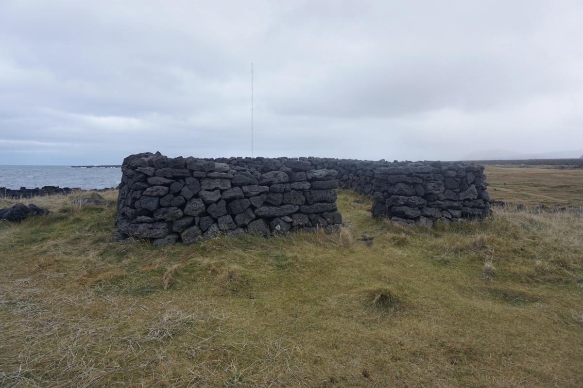
On a grassy stretch of Atlantic shoreline near Gufuskálar, the walls of Írskabyrgi form one of western Snæfellsnes's most intriguing small archaeological sites. Also written Írskrabyrgi and known as Malarbyrgi, the enclosure is built from dark, irregular volcanic stones. Its surviving walls frame an open, roofless interior, with a notably curved end and a passage into the enclosed space. The dramatic contrast between the black rock, pale grass and sea makes it rewarding to photograph in soft daylight. The official coastal archaeological inventory identifies this as site 1851-42. Researchers recorded a stone enclosure measuring roughly eight by eight metres and noted an entrance on the western side. Importantly, its walls have been rebuilt. That means it is not possible to assign a precise construction date—or identify its original purpose—from its present appearance alone. A chapel has sometimes been imagined because of the form and the name, but a church or early Irish monastic origin has not been established. The ruin sits in a rich archaeological landscape. Gufuskálar was once a significant fishing settlement; visitors can also explore the area around Írskrabrunnur, a historic well with sixteen descending steps, and Gufuskálavör, the old coastal landing where marks made by boat keels remain visible in the rock. The national park describes a circular walk connecting these places and the former fish-storage huts. Use the designated parking area in the Írskrabrunnur/Gufuskálar area, walk along existing tracks and approach the ruins carefully. The shore is exposed, the ground can be uneven and slippery, and the masonry is vulnerable to damage and erosion. Do not climb, dismantle, or sit on the walls. Unlike a reconstructed visitor attraction, Írskabyrgi is a fragile piece of real heritage whose unanswered questions are part of its significance.
Folklore
Story & Folklore
On the exposed shore at Gufuskálar stands a small enclosure built from dark lava stones, with the Atlantic Ocean only steps away. The place is known as Írskabyrgi—sometimes called Írskrabyrgi or Malarbyrgi—and its name has encouraged generations of speculation about an Irish presence on the peninsula. The shape is unusual: substantial walls enclose a roughly square area, and one end has a softer, curved outline. It is easy to imagine a chapel, but imagination is not archaeological proof. A formal coastal heritage survey records the remains as site 1851-42 and describes an approximately eight-by-eight-metre stone enclosure, with an entrance on its western side. Because the walls have undergone rebuilding, the surviving appearance cannot securely date the original structure. The wider Gufuskálar coast was once a busy fishing area, and nearby Írskrabrunnur and Gufuskálavör tell other chapters of that history. Today the quiet ruins are best appreciated at a respectful distance, with the wind, sea and landscape as part of the experience. This is a place to ask questions—not to pretend the answers are certain.
Did You Know?
The archaeological inventory identifies Írskabyrgi as site 1851-42 and records its enclosure as approximately 8 × 8 metres.
Culture
Stories & Legends
Icelandic sagas and folklore from this area

Explore
Hidden Gems Nearby
Írskrabrunnur
A historic well east of Írskabyrgi with a stone stairway descending sixteen steps. It was rediscovered and cleared in 1989.
A contrasting piece of Gufuskálar's water-supply and local-history heritage.
Gufuskálavör
The historic coastal landing where the rock still carries wear marks associated with boat keels.
Adds context about the fishing community that used this coast.
Gufuskálar fishing sheds
Remains of lava-stone fish-drying and storage structures inland from the shore near road 574.
An atmospheric look at the region's once-important maritime economy.
Help
Frequently Asked Questions
Location
Location
Discover
Explore Nearby
Places from our database within 5.0 km — all data from Sanity
Loading nearby places…
0 places found within 5.0 km
Plan full itinerary →Explore More