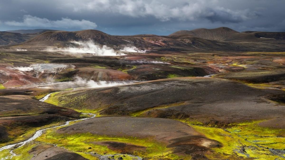
The Jarðhitasvæði við Torfajökul, or Torfajökull geothermal area, presents one of Iceland's most spectacular and active high-temperature geothermal fields, nestled deep within the remote south-central Highlands. This vast landscape, approximately 15 km long and 12 km wide, is a defining feature of the Fjallabak Nature Reserve. Visually, as depicted in the image, the area is a kaleidoscope of colors: rich reds and oranges of mineral-stained rhyolite hills contrast sharply with vivid green mosses and dark volcanic earth, all under a dramatic, often cloudy sky. White plumes of steam rise continually from numerous vents and hot springs, adding a dynamic, ethereal quality to the rugged terrain.
Geologically, Torfajökull is a rhyolitic stratovolcano with a massive caldera, dating back at least 384,000 years, making it Iceland's largest rhyolitic system. It's a place where the Mid-Atlantic Ridge rift zone meets the South Iceland seismic zone, explaining its intense geothermal activity. The last known eruption was in 1477, but a significant eruption around 870-877 AD produced the 'Settlement Layer' tephra, a crucial marker for dating Iceland's early settlement.
Visitors can explore a diverse array of geothermal phenomena, including steaming ground, boiling mudpots, shallow hot springs, and fumaroles. The colorful rhyolite mountains, sculpted by millennia of volcanic and geothermal processes, create a breathtaking backdrop. Due to the area's remote location and the delicate, potentially dangerous geothermal ground, it is imperative to stay on established routes and trails. This area is unexploited and used for environmental monitoring, so respect for nature is paramount. Prepare for a true wilderness experience, bringing all necessary supplies, as there are no services or reliable cell signal.
History
The geological history of Jarðhitasvæði við Torfajökul is deeply intertwined with Iceland's volcanic origins. At its heart lies the Torfajökull rhyolitic stratovolcano, a colossal system that began forming over 384,000 years ago. This area represents Iceland's largest rhyolitic system, covering an impressive 450 km², and lies at a critical geological junction where the Mid-Atlantic Ridge rift zone meets the South Iceland seismic zone, fueling its intense geothermal activity. The caldera itself spans 12-18 km, a testament to powerful ancient eruptions.
Beyond its geological grandeur, Torfajökull holds significant historical importance for human settlement in Iceland. A major eruption between 870-877 AD produced a widespread tephra layer, known as the 'Settlement Layer.' This geological marker is invaluable for archaeologists, helping to date early Icelandic archaeological finds, including the first longhouses in Reykjavík, to around 871 ± 2 AD. This aligns closely with the traditional settlement date of 874 AD found in Landnámabók, making the volcano a silent chronicler of the island's earliest human history.
The area's name also carries a historical echo; Landnámabók mentions Torfi Jónsson, who, according to legend, sought refuge by the volcano in 1493 during a plague. Today, the Torfajökull geothermal area remains an unexploited high-temperature geothermal field, designated for environmental monitoring and research since 1992, showcasing a living laboratory of Earth's ongoing processes.