
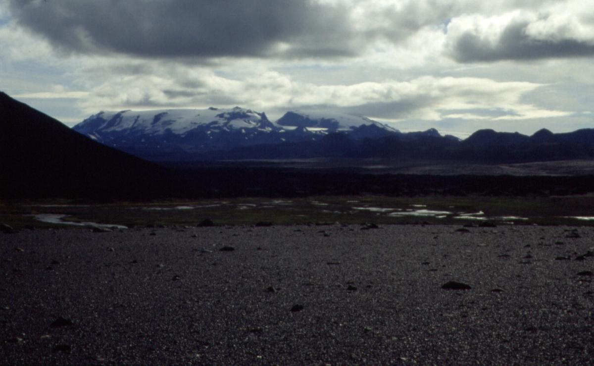
Kverkfjöll
A remote volcanic mountain range on Vatnajökull’s northern edge, where powerful geothermal heat, glaciers and highland wilderness meet.
At a Glance
Visit time
Half day to full day; allow more time or an overnight stay for longer marked hikes.
Best Season
Late June–August or early September, only after the highland roads have officially opened and conditions are suitable.
Getting There
Remote highland access by 4x4 only. F902 (Kverkfjallaleið) leads toward Kverkfjöll from the F910/F903 highland-road network. Check current road openings, river and weather conditions before departure; carry fuel, food and emergency supplies.
GPS
64.6530, -16.6511
About
About Kverkfjöll
A remote volcanic mountain range on Vatnajökull’s northern edge, where powerful geothermal heat, glaciers and highland wilderness meet.
Experience one of Vatnajökull National Park’s most powerful fire-and-ice landscapes, with a major active volcano, glaciers, geothermal features and true highland wilderness in one place.
Photos
Gallery
Background
History & Background
Kverkfjöll’s history is primarily geological. The mountain group is built around an active central volcano and bears clear evidence of repeated interaction between volcanic activity and Ice Age glaciers. Parallel hyaloclastite ridges, calderas, outlet glaciers and geothermal features record periods when eruptions took place beneath or beside ice. The modern landscape remains dynamic: geothermal heat melts glacier ice, marginal water bodies form and drain, and the glacier front retreats and shifts over time. The wider Vatnajökull region is internationally important for studying these fire-and-ice processes and is part of Vatnajökull National Park’s UNESCO World Heritage property. Human use of the Kverkfjöll area remains closely tied to highland travel. Today Sigurðarskáli, operated by Ferðafélag Fljótsdalshéraðs and Ferðafélag Húsavíkur, provides the principal visitor base, while national-park rangers work in Kverkfjöll during the summer and maintain interpretation and safety information for visitors.
Kverkfjöll is one of the most extraordinary volcanic-and-glacial landscapes in the Icelandic Highlands. The mountain range rises at the northern edge of Vatnajökull and forms part of a large active central volcano. According to Vatnajökull National Park, Kverkfjöll is Iceland’s third-highest mountain group after Öræfajökull and Bárðarbunga. Two ice-filled calderas are believed to lie within the system, with caldera rims around 1,800 metres. The highest summit, Skarphéðinstindur, reaches 1,936 metres. The range is divided by Kverk, a deep pass bordered by steep rock walls. Kverkjökull flows northwest through the pass and descends toward a plateau around 900 metres above sea level. Huge outlet glaciers frame the area: Dyngjujökull to the west and Brúarjökull to the east. The Kverkfjöll ridge itself contains parallel hyaloclastite ridges formed by volcanic activity interacting with ice, making the area a natural geological classroom. Geothermal heat is a defining feature. Vatnajökull National Park describes the Kverkfjöll geothermal system as one of the most powerful in Iceland. Hot water in the river Volga helps shape ice formations at the Kverkjökull margin, while meltwater can collect in geothermal lakes and drain suddenly. Because the glacier edge changes constantly, the national park urges extreme caution around the terminus. Its official visitor trail specifically warns people not to enter the unstable ice cave: falling ice is frequent and poisonous gases can accumulate quickly. The main summer visitor base is Sigurðarskáli, at about 900 metres elevation. The hut sleeps 75 people and there is camping, cooking facilities, toilets and showers. Rangers are stationed in the area during summer. There is no shop, restaurant or fuel station, so travellers must be self-sufficient. Access is by remote mountain roads, including F902 from the F910/F903 network, and a capable 4x4 is required. Road openings vary with snow and conditions, so current road and weather information should always be checked before departure. Visitors can choose from several official trails. The short K5 interpretive trail is approximately 800 metres and takes around 45 minutes. More demanding options include the 2.1 km Virkisfell route, the 9 km Biskupsfell loop and the trail toward Kverkjökull. Kverkfjöll is not a casual roadside stop, but for well-prepared highland travellers it offers a rare combination of active volcanism, geothermal energy, moving glaciers and immense wilderness.
Folklore
Story & Folklore
Kverkfjöll is a place where Iceland’s geology is still visibly at work. Beneath and between the mountains lies a powerful central volcano and geothermal system, while Vatnajökull presses around the range in vast masses of ice. Heat from below melts and reshapes that ice, feeding water into channels, marginal lakes and glacial rivers. At the northern side of the range, Kverkjökull descends through the great notch called Kverk toward the highland plateau. For travellers, reaching Kverkfjöll is part of the experience. The journey crosses remote mountain-road country far from fuel, shops and settlements. Sigurðarskáli provides a small summer base, but the surrounding landscape remains overwhelmingly wild. Short interpretive walks and longer marked routes reveal lava formations, moraines, volcanic rock, glacier margins and immense views. The famous ice formations at Kverkjökull are also a reminder that the landscape is not static: the glacier front changes constantly, ice can collapse without warning, and geothermal gases can accumulate. Kverkfjöll rewards careful, prepared visitors with one of Iceland’s clearest demonstrations of the continuing struggle between heat, ice and water.
Did You Know?
Kverkfjöll is Iceland’s third-highest mountain group, and its highest summit, Skarphéðinstindur, rises to 1,936 metres above sea level.
Explore
Hidden Gems Nearby
K5 — Fire and Ice visitor trail
An approximately 800 m interpretive walk near Kverkjökull that takes about 45 minutes and explains glacial terrain, geothermal activity, moraines and the changing glacier margin.
It gives visitors a concentrated introduction to Kverkfjöll’s geology without committing to one of the longer mountain hikes.
Virkisfell viewpoint
A 2.1 km challenging out-and-back route from Sigurðarskáli to Virkisfell, which reaches 1,108 m.
The summit gives broad views across the glacier, volcanic formations and the highlands north of Vatnajökull.
Biskupsfell circuit
A 9 km challenging loop from Sigurðarskáli taking around 4–5 hours, continuing beyond Virkisfell toward Biskupsfell.
It is one of the best marked longer hikes for seeing the scale of the Kverkfjöll highland landscape.
Help
Frequently Asked Questions
Location
Location
Discover
Explore Nearby
Places from our database within 5.0 km — all data from Sanity
Loading nearby places…
0 places found within 5.0 km
Plan full itinerary →Explore More