
Álftaversgígar
Explore Álftaversgígar, a stunning field of protected pseudocraters formed by Eldgjá lava over ancient wetlands.
At a Glance
Visit time
1-2 hours
Best Season
Late Spring to Early Autumn (May-September)
Getting There
Accessible via gravel roads, typically passable by 2WD vehicles in summer, though 4WD is recommended for exploring surrounding areas. Parking is usually available near designated viewing points.
GPS
63.5185, -18.5023
About
About Álftaversgígar
Explore Álftaversgígar, a stunning field of protected pseudocraters formed by Eldgjá lava over ancient wetlands.
Discover one of South Iceland's most striking and well-preserved pseudocrater landscapes, a testament to ancient volcanic power.
Tours Near Álftaversgígar

South Coast Tour - Black Sand Beach, Plane wreck, Skogafoss, Seljalandsfoss guided in Chinese冰岛南岸黑沙滩飞机残骸中文一日团
Magic Iceland Travel · 10 hours 30 minutes
South Coast Waterfalls, Glacier & Black Sand Beach Tour
BusTravel Iceland · 10 hours
South Coast Small Group Tour: Waterfalls, Glacier & Black Sand Beach
BusTravel Iceland · 10 hours
Private South Coast tour
EastWest · 10 hours
Photos
Gallery
Background
History & Background
The history of Álftaversgígar is deeply intertwined with one of Earth's largest volcanic events in recorded history: the Eldgjá eruption. This colossal fissure eruption, occurring between approximately 934 and 940 CE, released an immense volume of lava that flowed across vast swathes of South Iceland. As these superheated lava flows from Eldgjá encountered the waterlogged wetlands of the Álftaver region, a spectacular geological phenomenon unfolded. The interaction of molten rock with abundant water triggered violent steam explosions. Instead of erupting from a central volcanic vent, these explosions built up conical mounds directly on the surface, creating what geologists call pseudocraters, or rootless cones. These formations are unique because they are not connected to a magma source beneath the earth, but rather are a secondary product of lava-water interaction. Today, Álftaversgígar stands as a protected natural monument, safeguarding this rare and visually stunning testament to ancient volcanic activity. Its significance extends beyond geology, as the elevated terrain provided by these cones has historically offered a degree of protection to the Álftaver settlement from devastating glacial outburst floods associated with the powerful Katla volcano.
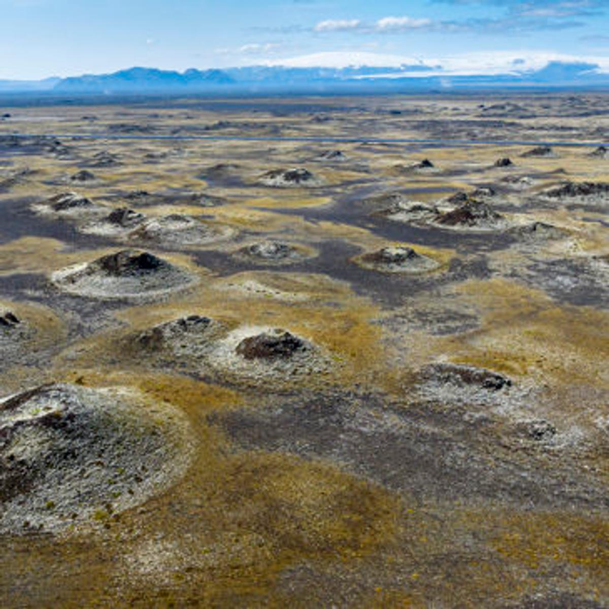
Álftaversgígar, meaning 'the craters of Álftaver,' is a truly remarkable natural monument nestled in the Álftaver region of South Iceland, east of Mýrdal. This vast field of pseudocraters, also known as rootless cones, presents a landscape unlike any other. Formed during the monumental Eldgjá eruption around 934–940 CE, these distinctive cones arose when scorching lava flowed over water-saturated ground. The intense heat caused the water to flash into steam, leading to explosive bursts that built up these conical formations without an underlying magma chamber or direct volcanic vent. The image vividly captures the scattered, dark, conical mounds contrasting with the lighter, often yellowish-brown, surrounding terrain, under a vast Icelandic sky. Beyond their striking geological beauty, these raised pseudocrater fields have played a crucial role in protecting the nearby Álftaver settlement from certain glacial outburst floods (jökulhlaups) originating from Katla. Visiting Álftaversgígar offers a profound insight into Iceland's dynamic geological history, its unique wetland ecosystems, and the enduring relationship between humans and their dramatic environment. It's a protected natural monument, inviting visitors to ponder the sheer power of nature that forged this incredible landscape.
Folklore
Story & Folklore
Imagine a land reshaped by fire and water, nearly a millennium ago. Around 934–940 CE, the colossal Eldgjá eruption unleashed rivers of molten rock across South Iceland. Here, in the Álftaver region, these fiery flows encountered vast, ancient wetlands. The superheated lava instantly vaporized the water, creating immense pockets of steam that exploded upwards, not from a true volcanic vent, but from the very ground itself. Each explosive burst built a conical mound, a 'rootless' pseudocrater. Today, these dark, scattered cones, visible against the lighter, yellowish-brown terrain in the image, stand as silent sentinels of that epic clash. They tell a story of geological drama, shaping not only the landscape but also inadvertently offering protection to the nearby Álftaver settlement from glacial floods, a compelling narrative of nature's power and its unexpected benefits.
Did You Know?
Álftaversgígar formed when hot lava met waterlogged ground, creating steam explosions rather than erupting from individual vents.
Explore
Hidden Gems Nearby
Lava Field Flora
Amidst the stark pseudocraters, discover resilient mosses and hardy grasses clinging to life, creating unexpected pockets of vibrant green and yellow. These plants showcase nature's ability to reclaim even the most extreme environments.
It's a beautiful contrast to the dark lava, highlighting the delicate ecosystem thriving on ancient volcanic ground.
Distant Katla Views
On a clear day, from certain vantage points within the pseudocrater field, you might catch a glimpse of the distant, ice-capped peak of Katla volcano. This offers a stark reminder of the powerful forces that shaped this entire region.
Connects the pseudocraters directly to the larger volcanic landscape of South Iceland.
Birdwatching along the Wetlads
While the pseudocraters themselves are dry, the surrounding Álftaver region is known for its wetlands. Keep an eye out for various bird species, especially migratory birds, that frequent the nearby marshes and ponds.
Offers a chance to experience the area's biodiversity beyond its geology.
Help
Frequently Asked Questions
Location
Location
Discover
Explore Nearby
Places from our database within 5.0 km — all data from Sanity
Loading nearby places…
0 places found within 5.0 km
Plan full itinerary →Explore More