Capital Region
Gullkistugjá
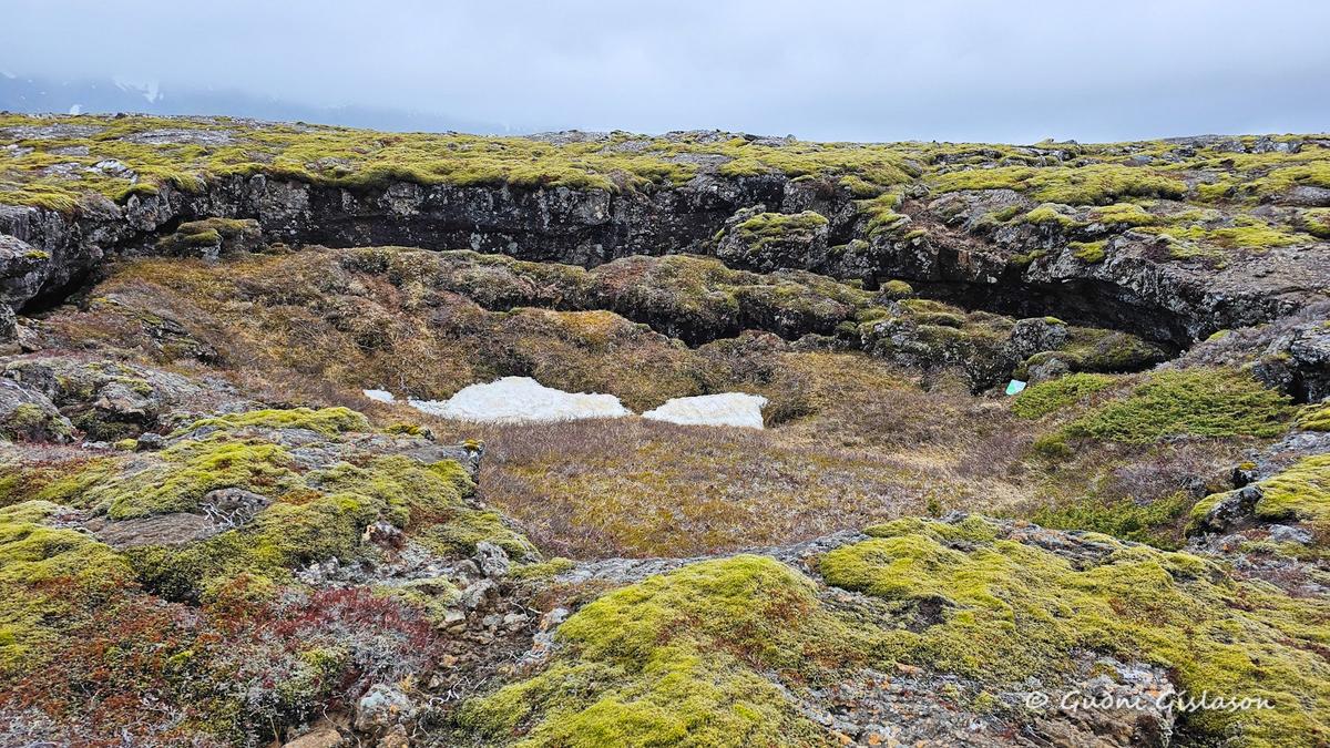
About Gullkistugjá
Gullkistugjá (Helgafell) is a prominent volcanic fissure located west of Helgafell above Hafnarfjörður, within a rugged lava landscape shaped by past eruptions on the Reykjanes Peninsula. The feature forms part of a long fracture system that cuts across the terrain, extending through the southeastern part of Helgafell and continuing southward through the surrounding lava fields. These fissures were created by tectonic movement and volcanic activity, which gradually split and reshaped the surface of the land over time. The surrounding area is characterized by uneven lava formations, cracks, and moss-covered rock, providing a clear view of Iceland’s dynamic geological processes. One of the most notable nearby features is Skúlatún, a small, unburnt grassy mound that stands in contrast to the otherwise dark and barren lava field. This isolated patch of vegetation highlights how soil and moisture can accumulate in sheltered spots, allowing plant life to develop even in challenging volcanic environments. Gullkistugjá is less visited than more famous geological sites in Iceland, offering a quieter and more remote experience for those exploring the trails around Helgafell. The area is accessible on foot and forms part of a wider network of walking routes above Hafnarfjörður. For visitors, it provides an opportunity to observe the interaction between tectonic forces, volcanic history, and gradual ecological development in a landscape that continues to evolve over time.
🐉 A long volcanic fissure west of Helgafell, Gullkistugjá cuts through lava fields above Hafnarfjörður, revealing the powerful geological forces shaping the Reykjanes landscape.
West of Helgafell, the land opens into a rugged lava field marked by deep cracks and uneven terrain. Among these features, Gullkistugjá stands out as a long fissure stretching through the landscape, quietly recording the movement of the earth beneath. For generations, people crossing this area would have noticed the dramatic contrast between the dark lava and the occasional patches of green, such as nearby Skúlatún, where vegetation has taken hold. The fissure itself is not a single dramatic canyon but a system of fractures that guide the eye across the terrain, showing how the land has slowly pulled apart over time. Today, visitors who walk the paths around Helgafell encounter Gullkistugjá as part of a broader volcanic landscape—one that feels both raw and untouched, offering a glimpse into the ongoing geological processes that continue to shape Iceland.
📖 History of Gullkistugjá
Gullkistugjá formed as part of the volcanic and tectonic activity associated with the Reykjanes Peninsula, where the Earth’s crust is gradually stretching and fracturing. The fissure developed over time as lava flows cooled and the ground shifted, creating cracks and fracture zones across the surface. Located near Helgafell above Hafnarfjörður, it is part of a wider system of geological features that reflect Iceland’s position along the Mid-Atlantic Ridge. Although not developed as a major tourist site, Gullkistugjá remains an important natural feature that illustrates the long-term geological processes shaping the region.
✈️ Why Visit
Visit Gullkistugjá (Helgafell) to explore a dramatic volcanic fissure in a quieter setting above Hafnarfjörður, where raw lava landscapes, deep cracks, and unique features like nearby Skúlatún reveal the powerful geological forces shaping Iceland.
💡 Did You Know?
Small green areas like Skúlatún can form in lava fields where soil and moisture accumulate over time—creating isolated patches of vegetation surrounded by bare volcanic rock.
Key Facts
Iceland was formed by volcanic activity approximately 16-18 million years ago
Gullkistugjá showcases Iceland's remarkable geological diversity
Iceland sits where the Eurasian and North American tectonic plates meet
🕐 Best Time
Late spring to early autumn (May–September) offers the safest and most accessible conditions, with clear paths and good visibility across the lava fields. Summer provides long daylight hours, ideal for exploring the area around Helgafell.
🚗 Access
Gullkistugjá is located west of Helgafell above Hafnarfjörður and is accessible on foot via hiking routes in the surrounding lava fields. There are no formal paved paths directly to the fissure, so visitors should follow established walking trails from nearby parking areas and use caution when navigating uneven terrain.
📍 GPS Location
Explore Tours Near Gullkistugjá
Find guided tours, day trips and activities. Compare prices and book instantly with free cancellation.