Capital Region
The First Krýsuvík Road
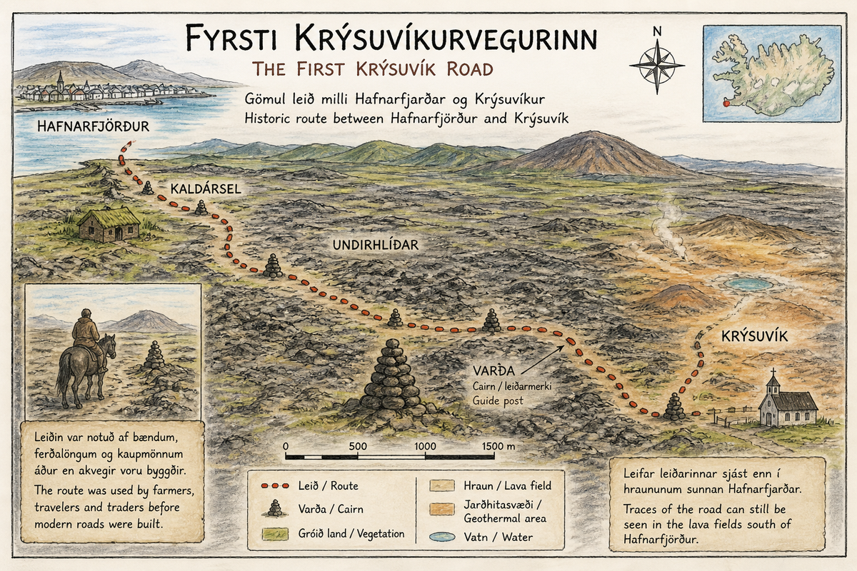
About The First Krýsuvík Road
The First Krýsuvík Road (Fyrsti Krýsuvíkurvegurinn) was an important historic travel route connecting the coastal settlement of Hafnarfjörður with the inland area of Krýsuvík across the rugged lava landscapes of the Reykjanes Peninsula. Long before modern roads were built, this path formed part of a wider network of traditional routes used by farmers, fishermen, traders, and travelers moving between coastal communities and inland resource areas. The route crossed young lava fields, uneven terrain, and open grazing lands where navigation depended on experience and carefully placed stone cairns (varða) that guided travelers through the landscape in all seasons. It provided access not only to farms and church sites in Krýsuvík but also to important grazing areas and geothermal resources that were valuable to nearby communities. Despite the difficult conditions, the road remained a reliable connection between settlements for generations. Sections of the old road can still be traced today near Kaldársel and across surrounding lava fields south of Hafnarfjörður. These preserved traces offer visitors insight into how people once traveled across the Reykjanes Peninsula before the development of modern infrastructure. Walking along parts of the route provides a unique opportunity to experience the historic landscape much as earlier travelers would have encountered it centuries ago.
🐉 The First Krýsuvík Road was an early travel route linking Hafnarfjörður with Krýsuvík, guiding travelers across lava fields long before modern roads reached the Reykjanes Peninsula.
For generations, people traveled the First Krýsuvík Road on foot and horseback between Hafnarfjörður and Krýsuvík, following a route shaped by experience rather than engineering. The journey crossed young lava fields and open highland terrain where travelers depended on stone cairns (varða) to navigate safely through changing weather and poor visibility. The road connected fishing communities on the coast with inland farms, grazing areas, and church sites, making it an essential pathway in everyday life. Even though the journey could be difficult, it helped maintain communication and cooperation between settlements across the Reykjanes Peninsula. Today, visible traces of the route near Kaldársel allow visitors to follow parts of this historic path and imagine how earlier generations once crossed the volcanic landscape of southwest Iceland.
📖 History of The First Krýsuvík Road
The First Krýsuvík Road developed as part of Iceland’s traditional network of travel routes used before the construction of modern roads in the 19th and early 20th centuries. It provided a reliable connection between Hafnarfjörður and the farming and church settlement at Krýsuvík, supporting seasonal movement, trade, and communication between communities. As improved transport infrastructure was introduced during the 20th century, the original route gradually fell out of regular use. However, sections of the old road remain preserved in the landscape today as cultural heritage features that reflect early transportation history on the Reykjanes Peninsula.
✈️ Why Visit
Fyrsti Krýsuvíkurvegurinn are historic ruins in Capital Region, Iceland, offering a glimpse into the lives of early Icelandic settlers and the country's long history.
💡 Did You Know?
Before modern roads existed, travelers on the First Krýsuvík Road between Hafnarfjörður and Krýsuvík often navigated by following cairns (varða)—small stone markers placed across the lava fields to guide people safely through the rugged volcanic landscape in poor weather and winter conditions?
📍 GPS Location
Explore Tours Near The First Krýsuvík Road
Find guided tours, day trips and activities. Compare prices and book instantly with free cancellation.