Haugahólar
Witness the immense power of nature at Haugahólar, a massive ancient landslide creating a dramatic, crater-like landscape.
About
About Haugahólar
Witness the immense power of nature at Haugahólar, a massive ancient landslide creating a dramatic, crater-like landscape.
Explore one of Iceland's largest landslides, a breathtaking geological wonder with a scenic hiking trail.
Photos
Photo Gallery
Background
History & Background
Haugahólar's history is written in the very landscape itself, a testament to the powerful geological forces that have continuously shaped Iceland. Approximately 16-18 million years ago, Iceland began to form through intense volcanic activity, situated uniquely on the Mid-Atlantic Ridge where the Eurasian and North American tectonic plates diverge. The specific formation of Haugahólar is attributed to a geologically recent, but still ancient, massive landslide. It's considered one of the largest in Iceland, resulting from the catastrophic collapse of the western flank of Haugafjall mountain. This event unleashed an immense volume of rock and debris into the valley below, creating the distinctive 'landslide hills' (hlauphólar) that characterize the area today. The diverse rock types found here – basalt, rhyolite, and scoria – are direct evidence of the complex volcanic origins of the region. Over millennia, nature has slowly reclaimed parts of the barren landslide terrain. Thin layers of soil have formed, allowing resilient grasses, mosses, and low-growing birch scrub to take root, particularly in the more sheltered depressions. Today, Haugahólar stands not only as a dramatic geological monument but also as a valued natural area, integrated into local tourism initiatives like the "Pearls of Fljótsdalshérað" hiking project, allowing visitors to explore its unique beauty and understand the profound geological history of East Iceland.
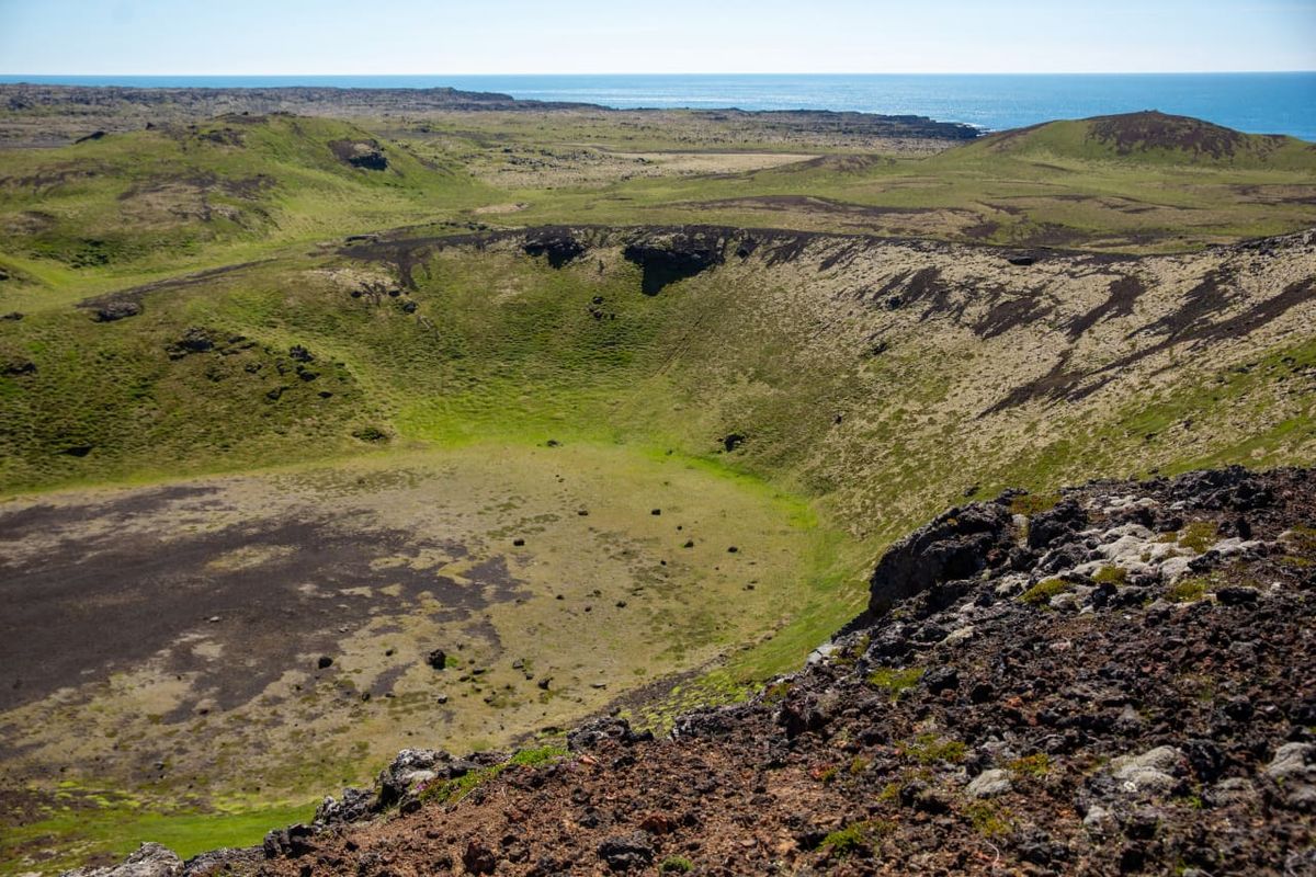
Haugahólar is a truly remarkable geological site in East Iceland, representing one of the country's most significant landslides. Formed when the entire western slope of Haugafjall mountain collapsed into the valley between Stuttadalur and Vatnsdalur, this colossal event created a vast landscape of 'landslide hills' (hlauphólar) spanning an impressive 400-500 hectares. The visual impact is striking, as seen in the image, with a large, green-carpeted depression resembling a massive crater, surrounded by rugged terrain of dark, multi-colored volcanic rock. The area is characterized by a mix of basalt, rhyolite, and scoria, often covered by thin soil and sparse vegetation, except in the sheltered depressions and dales where low-growing birch scrub thrives, adding pockets of lush greenery to the otherwise stark volcanic beauty. The foreground of the image clearly shows the rich textures of these rocks, adorned with patches of light-colored lichen, contrasting with the vibrant green beyond. Haugahólar is also an integral part of the "Pearls of Fljótsdalshérað" hiking project. A relatively easy 7 km trail leads from a road near the Haugur farm, winding through the Haugahólar formations and continuing into Stuttadalur. The journey culminates at a picturesque pond in the mouth of Stuttadalur, where hikers can find an information cylinder and a guestbook, offering a moment of reflection amidst the grandeur. This hike provides an intimate experience of the unique geology and serene natural beauty of East Iceland, with panoramic views extending towards the distant, shimmering ocean on clear days.
Folklore
Story & Folklore
Imagine standing at the edge of Haugahólar, gazing into the vast, bowl-shaped depression that stretches before you, carpeted in vibrant green moss and punctuated by dark volcanic rock. The air is crisp, carrying the scent of the wild, and the distant shimmer of the Atlantic Ocean reminds you of Iceland's untamed coastline. You can almost hear the echoes of the colossal event that shaped this land – a massive landslide, born from the heart of Haugafjall, tearing through the valley. It's a place where the earth's raw power is palpable, yet now, tranquility reigns, inviting you to wander the gentle slopes of the ancient debris, a silent witness to millions of years of geological drama. Every step on the path feels like a journey through time, revealing the island's dynamic past.
💡 Did You Know?
Haugahólar is one of Iceland's largest known landslides, covering an immense area of 400-500 hectares, showcasing diverse volcanic rock types.
Culture
Stories & Legends
Icelandic sagas and folklore from this area
Explore
Hidden Gems Nearby
✦ The Stuttadalur Pond
At the end of the 7 km hiking trail, discover a tranquil pond nestled in the valley. It's a perfect spot for quiet contemplation and to find the guestbook.
Offers a serene reward after the hike, with an information cylinder and guestbook.
✦ Varied Volcanic Rock Formations
Keep an eye out for the diverse types of volcanic rocks – basalt, rhyolite, and scoria – that make up the landslide. Their colors and textures tell a story of ancient eruptions.
A fascinating display of Iceland's geological diversity, perfect for rock enthusiasts.
✦ Lichen-Covered Boulders
The dark volcanic rocks are often adorned with intricate patterns of light-colored lichen. These hardy organisms create beautiful, subtle art on the rugged landscape.
Adds a delicate layer of beauty and ecological interest to the dramatic scenery.
Help
Frequently Asked Questions
Location
📍 Location
Discover
Explore Nearby
Places from our database within 1.0 km — all data from Sanity
Loading nearby places…
0 places found within 1.0 km
Plan full itinerary →Explore More