About
About Hagavatn
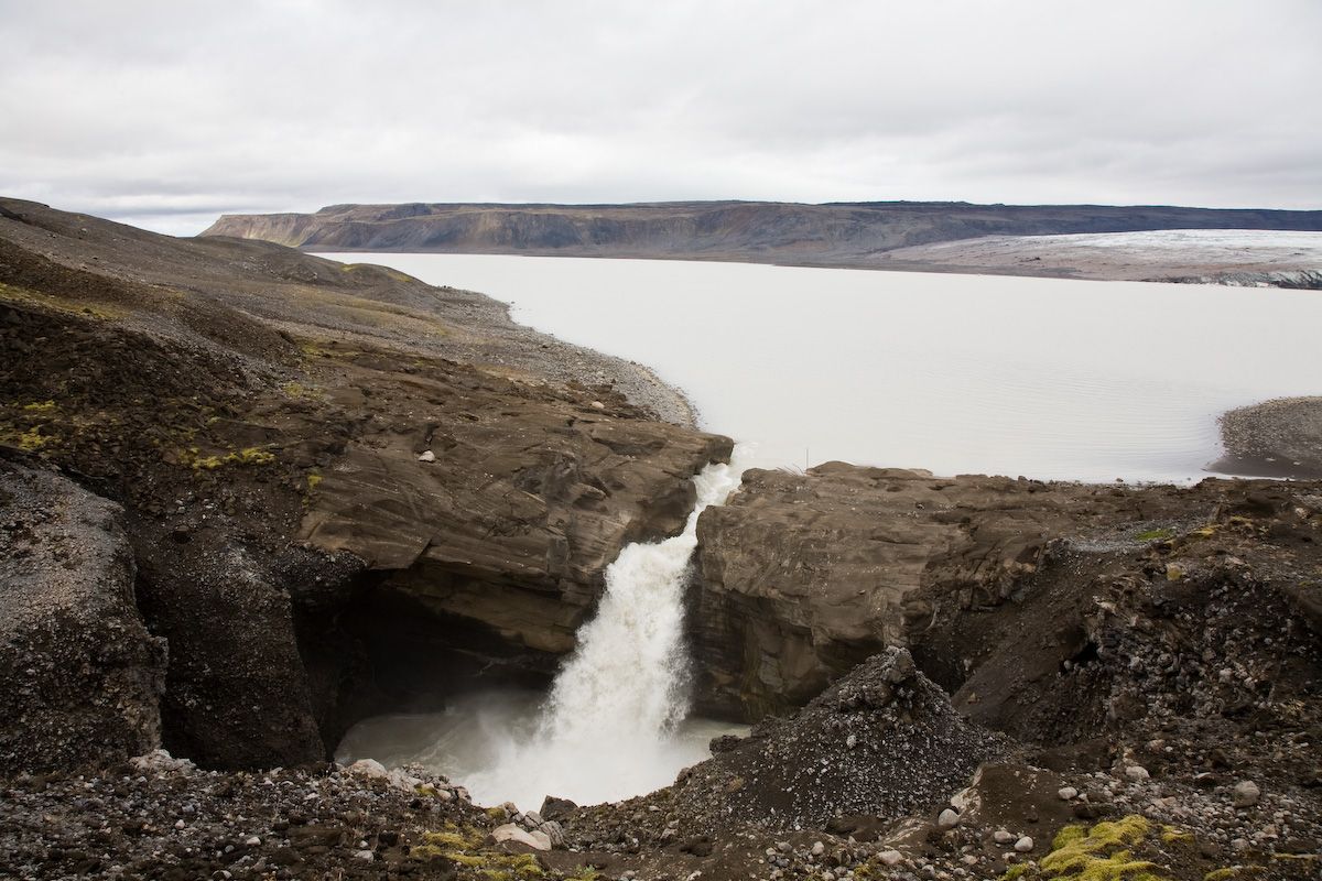
Remote glacial lake south of Langjökull in a stark highland landscape.
Experience the raw power of a glacial lake actively shaping its dramatic volcanic surroundings.
Photos
Photo Gallery
Background
History & Background
The history of Hagavatn and its surroundings is deeply intertwined with Iceland's volcanic and glacial activity. Geologically, the area is defined by features like the Brekknafjöll and Fagradalsfjall, which are ancient móberg ridges and mountains formed during subglacial eruptions. The Jarlhetturnar, a series of móberg peaks, further illustrate the region's volcanic origins along the Langjökull ice cap, showing the immense power that has shaped this land over millennia. A significant historical detail is the existence of Héðinsskógur, a thriving forest that once covered this seemingly desolate landscape. This forest was tragically destroyed in the powerful Hekla eruption of 1693, an event that dramatically altered the local ecosystem and left behind the more barren, rocky terrain visible today. This transformation highlights the immense and lasting impact of Iceland's volcanic forces on its environment and how quickly landscapes can change. In more recent times, Hagavatn itself has become a living testament to environmental change. Over the past decades, the lake has considerably diminished in size, a direct consequence of the ongoing retreat of the Langjökull glacier due to climate change. This makes Hagavatn not just a site of natural beauty, but also a poignant reminder of the planet's changing climate and the dynamic, often fragile, nature of Iceland's glacial landscapes.
Hagavatn lies south of Langjökull in a remote highland setting. The lake developed and changed as nearby glacier margins retreated, leaving exposed sediment, rough terrain and changing drainage channels. Access is not comparable with a normal roadside attraction and depends on seasonal road and weather conditions; travellers should check current highland access before setting out.
Folklore
Story & Folklore
Beneath the vast, often brooding skies of South Iceland lies Hagavatn, a glacial lake born from the immense Langjökull ice cap. Its milky waters, charged with glacial silt, tell a story of ancient ice and relentless erosion. Stand at its edge, and you feel the raw power of nature as the lake's outflow dramatically plunges into a rocky chasm, creating a thundering waterfall. This dynamic landscape, where dark volcanic rock meets the pale, ethereal expanse of the water, hints at a past far grander and wilder. Once, a forest thrived here before Hekla's fiery breath transformed the land. Now, the shrinking lake serves as a vivid, poignant reminder of the continuous, powerful forces shaping this extraordinary island.
💡 Did You Know?
Did you know that Hagavatn's surrounding area once boasted a forest called Héðinsskógur, destroyed by the Hekla eruption in 1693? The lake itself has significantly shrunk in recent decades.
Location
📍 Location
Discover
Explore Nearby
Places from our database within 1.0 km — all data from Sanity
Loading nearby places…
0 places found within 1.0 km
Plan full itinerary →Explore More