Gigjukvisl Bridge Memorial
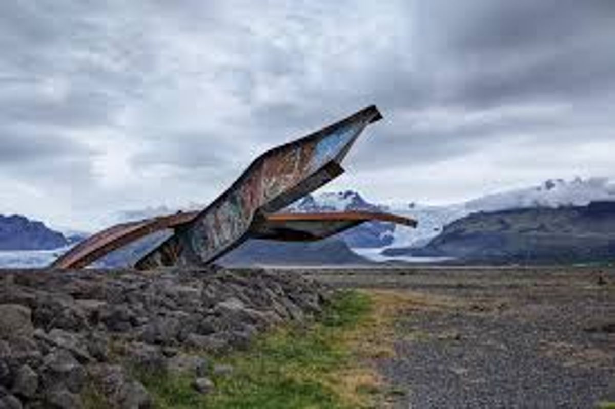
Bridge remains preserved beside Route 1 after the destructive 1996 Skeiðarársandur jökulhlaup.
At a Glance
Visit time
30-45 minutes to explore the site and read the information boards.
Best season
Daytime, any season (be prepared for strong winds and cold, especially in winter).
Access
Easily accessible directly from Ring Road (Route 1) with a dedicated parking area.
GPS
63.9399, -17.3649
About
About Gigjukvisl Bridge Memorial
Bridge remains preserved beside Route 1 after the destructive 1996 Skeiðarársandur jökulhlaup.
Experience the humbling scale of Iceland's geological forces through the dramatic wreckage of a once vital bridge.
Photos
Photo Gallery
Background
History & Background
The Gigjukvisl Bridge was a vital component of Iceland's Ring Road (Route 1), completed in 1974, providing a crucial link across the vast Skeiðarársandur outwash plain. Its construction was a significant engineering feat, enabling year-round travel along the south coast, which was previously often impassable due to glacial rivers. However, the bridge's fate was sealed by the powerful geological forces at play beneath Vatnajökull, Europe's largest glacier. In late September and early October 1996, a subglacial eruption occurred beneath the Grímsvötn caldera, deep within the glacier. This eruption caused massive amounts of meltwater to collect in the Grímsvötn subglacial lake. For weeks, the pressure built until, in early November, the lake burst, unleashing a colossal Jökulhlaup—a glacial outburst flood—that tore across the Skeiðarársandur plain. The flood peaked on November 5th, with a discharge rate estimated at 45,000 cubic meters per second, equivalent to the Amazon River's flow. The floodwaters, laden with icebergs up to 10-15 meters high and massive boulders, completely overwhelmed the bridge, tearing its massive steel trusses from their foundations and scattering sections across the plain. The remains you see today are left as a memorial to this incredible event and a testament to Iceland's dynamic nature.
A major jökulhlaup crossed Skeiðarársandur in November 1996 following volcanic activity beneath Vatnajökull. Floodwater, sediment and large blocks of glacier ice damaged roads and bridges, including the bridge over Gígjukvísl. Sections of twisted steel were retained beside the rebuilt Ring Road as a reminder of the event and of the hazards created by subglacial eruptions.
Folklore
Story & Folklore
In the autumn of 1996, beneath the Vatnajökull glacier, a subglacial volcano erupted, melting vast quantities of ice. Days later, an unstoppable torrent of water, ice, and debris—a Jökulhlaup—burst forth, sweeping across the Skeiðarársandur outwash plain. The mighty Gigjukvisl Bridge, a crucial link on the Ring Road, stood no chance. Its steel and concrete were twisted and torn like paper, leaving behind the mangled remains you see today. These rusted fragments, set against the stark beauty of the glacial landscape, tell a silent, powerful story of nature's overwhelming force and human resilience in its wake. It's a poignant reminder that in Iceland, the land always has the final word.
💡 Did You Know?
The 1996 Jökulhlaup (glacial outburst flood) that destroyed this bridge was so powerful it moved icebergs the size of multi-story buildings.
Explore
Hidden Gems Nearby
✦ Skeiðarársandur Outwash Plain
Explore the vast, flat expanse of black sand and gravel surrounding the memorial. This desolate landscape was formed by countless glacial floods over millennia.
It showcases the immense scale of glacial erosion and deposition.
✦ Skaftafell Nature Reserve
Just a short drive east, Skaftafell offers stunning hiking trails, including paths to Svartifoss waterfall and views of Vatnajökull glacier's outlets.
A beautiful area for hiking and experiencing diverse Icelandic landscapes close to the memorial.
Help
Frequently Asked Questions
Location
📍 Location
Discover
Explore Nearby
Places from our database within 1.0 km — all data from Sanity
Loading nearby places…
0 places found within 1.0 km
Plan full itinerary →Explore More